
Drone Mapping Curriculum for High School: Preparing Students for GIS Careers
While learning to fly a drone is an exciting and engaging experience for students, the true commercial value of drone operations lies not in the flight itself, but in the data collected from the air. As the drone industry matures, basic flight skills are becoming a baseline expectation rather than a unique differentiator. The most lucrative and high-demand career pathways now require advanced technical skills in data acquisition and analysis.
Unfortunately, many high school drone programs focus solely on basic flight maneuvers, recreational racing, or simple aerial photography. By stopping there, educators are missing a massive opportunity to introduce students to the highly technical fields of mapping, surveying, and Geographic Information Systems (GIS). These are the sectors where the most significant industry growth and the highest salaries are currently found.
This guide explores why implementing a specialized drone mapping curriculum for high school is essential for forward-thinking CTE programs. We will discuss how educators can move beyond basic flight instruction to prepare students for high-demand, data-driven careers in infrastructure, agriculture, and urban planning.

The Rise of Drone Mapping and Surveying Careers
To understand the importance of a drone mapping curriculum, we must look at how industries are transforming. Sectors like construction, agriculture, mining, and civil engineering are rapidly shifting away from traditional, time-consuming surveying methods. Instead, they are adopting drones to capture highly accurate spatial data in a fraction of the time.
The GIS and spatial data industry is experiencing explosive growth. Companies are desperate for professionals who understand how to capture aerial data, process it using specialized software, and translate it into actionable insights. Students who graduate high school with a foundational understanding of these processes possess a massive competitive advantage in the modern job market.
These careers offer significant earning potential and long-term stability. A drone mapping curriculum for high school introduces students to concepts like photogrammetry, volumetric measurements, and topographical analysis—skills that translate directly into high-paying roles as GIS technicians, survey technicians, or specialized commercial drone pilots.
What Makes a Strong Drone Mapping Curriculum?
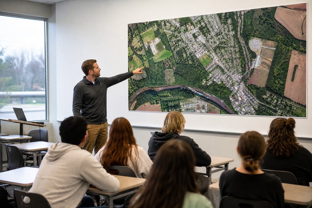
A strong mapping curriculum must go far beyond teaching students how to manually pilot a drone. In fact, in professional mapping operations, the drone flies itself. The curriculum must focus on automated flight planning, waypoint navigation, and the critical parameters of data capture, such as image overlap, altitude, and camera angles.
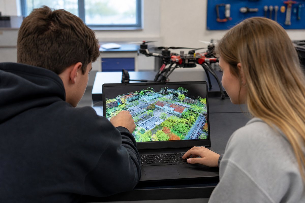
More importantly, the curriculum must heavily emphasize the post-flight data processing phase. Capturing the images is only the first step; the real work happens on the computer. Students must learn how to use photogrammetry software to stitch hundreds of aerial photos together into accurate 2D orthomosaics and detailed 3D models.

The Data Processing Gap
Flying the drone is only 20% of the job. A true mapping curriculum spends 80% of the time teaching students how to process the captured images into actionable 2D orthomosaics and 3D models.
Educators need a curriculum that provides clear, step-by-step instruction on these software platforms. It should include realistic datasets for students to practice with, ensuring they understand how to troubleshoot processing errors, measure distances and volumes accurately, and export data in formats used by industry professionals.
Integrating GIS into High School CTE Programs
One of the greatest strengths of a drone mapping curriculum is its versatility. It does not need to exist in a silo; rather, it can be seamlessly integrated into existing CTE pathways to enhance the learning experience and provide modern, technological context to traditional subjects.
For example, in a civil engineering or architecture pathway, students can use drone mapping to survey a mock construction site, analyze the topography, and plan a building layout based on real-world spatial data. In an agricultural science program, students can use multispectral mapping data to analyze crop health, identify irrigation issues, and calculate yield estimates.
“Adding a mapping module to our drone program changed everything. Students went from just flying around to actually analyzing spatial data and presenting topographical reports.”
— Marcus Chen, High School STEM Educator
By integrating mapping technology into these established pathways, educators provide students with a holistic understanding of how drones are used as professional tools. This cross-disciplinary approach not only increases student engagement but also ensures that the CTE program remains relevant and aligned with current industry standards.
The Importance of FAA Part 107 in Drone Mapping
While learning the technical skills of mapping is crucial, students must also understand the regulatory environment governing commercial drone operations. To legally fly mapping missions for any commercial purpose—which includes many internships, paid projects, or post-graduation employment—individuals must hold an FAA Part 107 Remote Pilot Certificate.
A comprehensive drone mapping curriculum for high school must include rigorous preparation for the FAA Part 107 exam. This certification covers essential topics such as airspace classifications, weather patterns, flight restrictions, and emergency procedures. It is the foundational credential that proves a pilot’s professionalism and legal compliance.
Because the minimum age to take the Part 107 exam is 16, high school students have the unique opportunity to graduate fully credentialed. By combining advanced mapping skills with the legal authority to fly commercially, educators are equipping their students with everything they need to step directly into the workforce or pursue advanced degrees with a significant head start.
Ready to Add Drone Mapping to Your CTE Program?
Drone Launch Learning provides the turnkey curriculum, software guidance, and professional development your teachers need to deliver world-class mapping instruction.
Getting Started with Drone Mapping in Your School
Implementing a drone mapping curriculum requires a strategic approach. The first step is ensuring that your students have achieved basic flight competency and are preparing for their Part 107 certification. Once that foundation is laid, you can introduce the specific hardware and software required for mapping operations.
Educational Software Licenses
Many leading drone mapping software companies offer heavily discounted or free educational licenses for high school CTE programs.
You will need to procure drones capable of executing automated waypoint missions; fortunately, many standard enterprise drones are well-suited for this task. Next, select a mapping software platform, such as DroneDeploy or Pix4D. Many of these industry-standard platforms offer educational licensing, making them highly accessible for school districts.
Finally, utilize a turnkey curriculum to guide your instruction. Teaching photogrammetry and GIS concepts from scratch can be overwhelming for educators without prior experience. A structured curriculum provides the lesson plans, datasets, and assessment rubrics necessary to deliver high-quality, industry-aligned education confidently.
Key Takeaways
- Drone mapping and GIS represent some of the highest-paying career pathways in the drone industry.
- A strong curriculum focuses heavily on data processing and photogrammetry, not just flight.
- Mapping integrates perfectly into existing civil engineering, architecture, and agriculture CTE pathways.
- FAA Part 107 certification is a non-negotiable requirement for commercial mapping operations.
- Turnkey curriculum solutions provide the software training and lesson plans educators need to succeed.
Conclusion
Implementing a drone mapping curriculum for high school elevates a standard aviation program into a highly technical, data-driven CTE pathway. It shifts the focus from the mechanics of flight to the analysis of spatial data, directly aligning student learning with the most lucrative sectors of the commercial drone industry.
By teaching students how to capture, process, and analyze aerial data, educators are preparing them for the future of infrastructure, agriculture, and urban development. With the right curriculum, software, and Part 107 preparation, your school can launch a program that provides students with unparalleled career readiness. Are you ready to bring professional drone mapping to your classroom?
Elevate Your Drone Program with Mapping
Book a demo to explore our advanced drone curriculum and Part 107 prep resources.